


Mount Kailash Altitude: How High is the Kora and How to Avoid Altitude Sickness?
Mount Kailash Altitude: How High is the Kora and How to Avoid Altitude Sickness?
![]() Altitude of Mount Kailash: How High is Mount Kailash?
Altitude of Mount Kailash: How High is Mount Kailash?
![]() Altitude of the Mount Kailash Kora: Changes along 3-day Trek
Altitude of the Mount Kailash Kora: Changes along 3-day Trek
![]() Altitude from Lhasa to Mount Kailash: Gradual Acclimatization along the Way
Altitude from Lhasa to Mount Kailash: Gradual Acclimatization along the Way
![]() Altitude from Nepal to Mount Kailash: Be Aware of Sudden Elevation Gain
Altitude from Nepal to Mount Kailash: Be Aware of Sudden Elevation Gain
![]() Tips to Prevent Altitude Sickness during Mount Kailash Kora Tour
Tips to Prevent Altitude Sickness during Mount Kailash Kora Tour
When taking a Mount Kailash tour, you will travel to very high altitudes. The 3-day kora trek around the mountain follows an average altitude of 5000 meters, with the highest point reaching 5630 meters. This can be a challenge, but if you travel from Lhasa to Mount Kailash, the gradual altitude increase gives you time to adjust and helps you get ready for the trek.
In this guide, we’ll explain everything about the altitude of a Mount Kailash tour. You’ll learn about the altitude changes during the kora, the route from Lhasa to Mount Kailash, and the route from Kathmandu. We’ll also share helpful tips to avoid altitude sickness. Keep reading to prepare for a safe and enjoyable journey!
Altitude of Mount Kailash: How High is Mount Kailash?
Situated in the far west of the Tibetan Autonomous Region, Mount Kailash rises to an impressive altitude of 6638 meters (21778 feet). While it is not the highest mountain in Tibet, it is considered the holiest across four major religions: Hinduism, Buddhism, Jainism, and Bon.
 Mount Kailash is the holiest mountain in four major religions.
Out of deep religious respect, climbing Mount Kailash is forbidden. Instead, pilgrims and believers from all over the world come here to complete the kora around the mountain, seeking merit, purification, and blessings. For ordinary tourists, the kora trek is also a meaningful experience, but good preparation is essential due to the high altitude.

Join our most popular Kailash Manasarovar tour for a smooth experience!
Altitude of the Mount Kailash Kora: Changes along 3-day Trek
The Mount Kailash Kora is a 52-kilometer loop usually completed in three days, moving in a clockwise direction. The trek begins in Darchen (4560 meters) and passes through several scenic valleys, before returning to Darchen. Along the way, you’ll climb to the highest point of the route, Dolma La Pass, which reaches an altitude of 5630 meters.
 Mount Kailash Outer Kora Altitude Change Chart
Trek Day 1: Darchen (4560m) - Darpoche (4750m) - Choku Monastery (4875m) - Dirapuk Monastery (5210m) (13km, 200m of climbing)
Your journey starts at Darchen, from where you’ll usually take an eco-bus to Sarshung Village before beginning the trek. After a few kilometers, you’ll reach Darboche (4750m), a sacred site where Tibetans gather each year to celebrate the holy Saga Dawa Festival.
 Local Tibetans celebrate the holy Saga Dawa Festival at Darboche of Mount Kailash.
The trek then continues up the valley to the first monastery along the kora - Choku Monastery (4875m). After a short rest, you’ll head toward to Dirapuk Monastery (5210m), which takes another three hours of walking up the valley. Here, you’ll begin to see the north face of Mount Kailash, and spend your first night of the kora in the peaceful site.
 North Face of Mount Kailash from Dirapuk Monastery
Trek Day 2: Dirapuk Monastery (5210m) - Drolma La Pass (5630m) - Gaurikund Lake (5608m) - Zutulpuk Monastery (4790m) (18km, 550m of climbing)
From Dirapuk, on the second day, you cross a small bridge onto the trail that leads to Shiwathal, a rocky field where sky burials are performed. The path then climbs steadily toward the highest point of the kora: Drolma La Pass (5630m). Many pilgrims leave tokens such as coins or tie prayer flags here as offerings.
 Our tourists are climbing over Drolma La Pass.
From the pass, the trail descends steeply to Gaurikund Lake (5608m), and then continues down into the lush Lham-chu Valley. Finally, the route follows the river to reach Zutulpuk Monastery (4790m), where you will spend the second night.
Trekking Day 3: Zutulpuk monastery(4790m) - Darchen (4560m) (14km)
The last day starts with an easy walk down the Dzong-chu Valley, which slowly narrows into a gorge decorated with prayer flags above the river. The final stretch of the trail to Darchen is a bit rough but easily manageable. In less than four hours after leaving Zutulpuk Monastery, you'll return to Darchen, completing your sacred Mount Kailash kora.
 View of Mount Kailash from Zutulpuk Monastery
Altitude from Lhasa to Mount Kailash: Gradual Acclimatization along the Way
One of the best ways to minimize the risk of altitude sickness during a Mount Kailash tour is to travel from Lhasa to Mount Kailash. This ideal route follows a gradual ascent in elevation, and gives you enough time to rest and adapt along the way. Lhasa, sitting at a lower altitude of 3650 meters, is also a popular entry point for most tourists visiting Tibet.
 Lhasa to Mount Kailash Altitude Change Chart
You can first spend a few days in Lhasa before heading west, allowing your body to acclimatize to the plateau altitude. The route then takes you westwards, with stops in Shigatse (3800m) and Saga (4487m), allowing you to gradually adapt to the higher elevations. By the time you reach Darchen (4560m), your body will be better prepared to handle the tough kora trek.
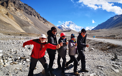
One added bonus of the route is that you can pay a visit to Mount Everest en route. Between Shigatse and Saga, you can take an extra day to Everest Base Camp (5000m). Here, you will enjoy a majestic up-close view of Mount Everest, and if weather permits, catch a stunning sunrise or sunset over the world’s highest peak.
 It is a good choice to visit Tibet Everest Base Camp on the away from Lhasa to Mount Kailash.
Join our most popular Kailash Manasarovar tour for a smooth experience!
Altitude from Nepal to Mount Kailash: Be Aware of Sudden Elevation Gain
If you are considering taking the Kailash Manasarovar Yatra from Nepal via Gyirong border, be prepared for a more challenging altitude transition. From Kathmandu (1400 meters) to Gyirong town (2700 meters) and then to Saga (4487 meters), the elevation rises quickly, all within just a day or two.
In this situation, it’s recommended to spend one night in Gyirong to give your body time to adjust. The journey from Kathmandu to Gyirong is quite exhausting, following a rugged mountain road, so a good rest in Gyirong Town can also help you recover your energy. While there, you can explore the lush Gyirong Valley before venturing into the higher, more barren plateau.
 You can visit Gyirong Valley druing Nepal to Mount Kailash tour.
Tips to Prevent Altitude Sickness during Mount Kailash Kora Tour
1. Prepare Yourself Physically Before the Trip
Before you head for Tibet, it is a good idea to assess your physical fitness and do a little training, as the Kailash trek is rough and arduous. Swimming, cycling, and running are great exercises and can build lung strength. You should also get a full physical exam before you depart for Lhasa.
2. Acclimatize Well in Lhasa
Once in Lhasa, take time to acclimatize before heading to Darchen. Rest well, avoid strenuous activity, and use the two days in Lhasa to let your body adjust. You should also try to avoid alcohol, strong coffee, and smoking, and make sure you remain hydrated.
3. Stay Hydrated and Rest Often During the Trek
Avoid smoking and drinking during the trek, as they can cause dehydration and raise the risk of altitude sickness. Stay well-hydrated, take regular breaks, and try to sleep at a lower altitude than the highest point you reach each day.
4. Eat Well and Avoid Alcohol or Smoking
At high altitudes, eat light meals with plenty of carbohydrates - they give you energy and are easier to digest. Avoid alcohol and smoking, as they make it harder for your body to adjust and can increase the risk of altitude sickness.
5. Prepare and Pack Medications
Some travelers use acetazolamide (Diamox) to help acclimatize - check with your doctor first. Also bring medicine for mild altitude sickness and common issues like headaches, fatigue, and motion sickness.
6. Dress in Layers for Comfort and Protection
Dressing in layers is a smart choice because the weather around Mount Kailash can be unpredictable. This lets you easily adjust to temperature changes and stay comfortable throughout your journey, helping to prevent colds.
7. Follow Your Guide’s Advice If Symptoms Appear
Your professional trekking guide is an essential aid in helping to recognize and manage altitude sickness, and all our guides are professionally trained in the treatment of individual symptoms. If you do feel any of the effects of altitude sickness, you should inform your guide immediately, and if the symptoms become more severe, he will recommend you move to a lower altitude immediately.
Join our most popular Kailash Manasarovar tour for a smooth experience!
Conclusion
A Mount Kailash kora tour is a high-altitude adventure, with the route reaching up to 5,630 meters. Whether you travel from Lhasa or Nepal, taking a gradual approach, practicing proper acclimatization, and listening to your body are key to enjoying this incredible trek safely.
As one of the leading Tibet tour operators with years of experience organizing Mount Kailash tours, we’re here to ensure your journey is smooth and worry-free. From permits to hotels, everything is taken care of by our seasoned local Tibetan guides and dedicated 24/7 support team. Feel free to contact us or book your tour today!


Ask a Quick Question